
Information Introduction to the Exmouth BMP Update
Content

Purpose of the BMP Update
The area that is covered by the BMP (below), from Orcombe Point to Exmouth Marina, is at risk of both coastal flooding and erosion.

The BMP sets out how these risks can be managed, and how the beach and coastal defences will be maintained going forwards.
Since the 2015 Exmouth BMP, there are a number of developments that now need to be considered, such as the:
- many more years of coastal monitoring data available, which need to be reviewed and analysed to further the understanding of beach dynamics and the processes of beach level lowering and recovery
- climate change guidance, that was updated in 2018 and changes to the assumed rates of sea level rise. This will impact on short and long-term beach and coastal defence management approaches
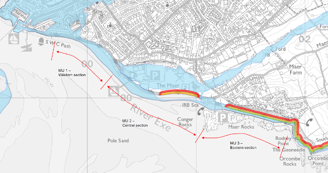
The map above illustrates the Exmouth BMP areas at risk of flooding and erosion in greater detail. The areas shared in blue are in the Environment Agency Flood Zone 3. The green line represents short-term erosion risks, the orange line indicates medium-term erosion risk, and the thick red lines show where there is longer-term erosion risk. The thinner red line with arrows divides the BMP area into three zones (western, central, and Eastern).
Project stages
This project to update Exmouth's BMP began in October 2023 and is currently anticipated to be completed by the end of 2024.
The project will be undertaken in stages, which have been summarised below:
- Stage 1 – Data is collected and reviewed to provide evidence that will inform the update to the BMP
- Stage 2 - The project team analyses natural processes to see how these are impacted by climate change, and what would happen if nothing was done to manage them
- Stage 3 - the latest technical, environmental and economic evidence will be used to review the 2015 BMP options. Environmental assessments and the 12-week public consultation are part of this stage
- Stage 4 - updated BMP documents will be produced and submitted for approval by EDDC’s Cabinet. Once approved, the updated BMP will be published and will guide the management of Exmouth's beach and coastal defences.
How you can help
Following the first drop-in event, which was held at Exmouth Town Hall on 15 February, attendees and anyone who was unable to make it there, are encouraged to share their feedback on the Commonplace survey website before 1 March.
Another drop-in session and a 12-week consultation will be taking place later this year.
Project team
EDDC's consultants AECOM are leading on the technical delivery of this project, and experts from the Environment Agency and BCP Council are providing support to the council.